

- The town of Mexican Hat is just 125 miles south of Moab.
- Take a hike and see the upside down sombrero that the town was named after.
- The San Juan River runs adjacent to town.
- Mexican Hat is the perfect stopping point on your way from Monument Valley to Arches National Park.
Overview
This small town is full of spirit and surrounded by some of the most beautiful landscape in all of Utah. Impressive rock formations dot the landscape, while one in particular is credited for the town's name, as it resembles an upside down sombrero. Most people use Mexican Hat as a base as they explore all the famous sights of the region.
Climb the famed Mexican Hat rock, venture out on day trips to national parks, raft the San Juan River or hit the trails outside of town, because in Mexican Hat, you have options. A trip to southeastern Utah would not be complete without a stop at this eclectic little town.
Location
Nestled along the San Juan River in southeastern Utah is where you will find the tiny community of Mexican Hat. The town is primarily a stopping over point for those on their way to Monument Valley, just 22 miles southwest, to Natural Bridges National Monument, 44 miles north, or to Moab, 125 miles slightly northeast.
Services/Amenities
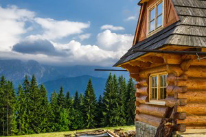
Although this town boasts less then 100 residents there are a surprising amount of services, relatively speaking of course. When you tire of all the sight-seeing and need a place to rest your head, you will find a handful of local options in Mexican Hat. Two offer great views of the San Juan River. Don't expect anything glamorous, think more along the lines of charming southwestern style and decor. During the spring and summer months, plan on making reservations.
There is one bed and breakfast north of town on the road to Valley of the Gods. Now, this is a wonderful place, isolated from the crowds and set among the quiet scenery of the Valley. A bit more expensive then other spots, but it shows in what you get and breakfast is included.
Campers and RV folks will find a RV park just outside of town. This site offers very limited amenities and luckily that's reflected in the low price.
If you are looking for a bite to eat, Mexican Hat has a couple of restaurants. The mainly American cuisine is carnivore heavy, but most places offer one or two traditional Navajo dishes, especially those that include fry bread. Restaurant liquor licenses are hard to come by in Utah, yet one restaurant in town holds the only one within 100 miles, go figure.
Activities
Sitting next to the San Juan River makes Mexican Hat the perfect place to start a rafting trip. Experience the twist and turns of this powerful river. Many tour companies run trips either starting or ending in Mexican Hat.
For rock climbing, head no further then Mexican Hat rock, a 60ft wide rock on a much smaller base. Two routes are already set, the Bandito Route and the Royal Robbins, found opposite each other. The hike to Mexican Hat rock from town is just three miles. Depending on your vehicle, it may be easier to hike than to drive.
There is a lot of hiking, biking, ATV trails and horseback riding available just outside of town, no need to hop in the car. Talk to the locals, bring lots of water and hit the trail.
Attractions
The Muley Point Overlook, just 13 miles northwest of town, provides outstanding views of the high country desert. In the far distance, you can even see the famous red rock formations of Monument Valley. While closer in, the power of the San Juan River is evident as you see the meandering, deep canyon walls and all of the smaller tributaries.
Eight miles west of Mexican Hat is Gooseneck State Park. From here, 1,000 ft above the river, witness the incredible 'gooseneck' series of turns in the San Juan River.
North of Mexican Hat you will find Valley of the God's. This sight is often described as a miniature version of Monument Valley because of its smaller yet similar isolated, tall, red mesas, buttes, and cliffs. Think fewer tourist and awesome views.
Getting Here
To find Mexican Hat, just head south. From Moab, head south on US-191 and merge onto US-163 S. Continue on US-163 S until you reach Mexican Hat. The highway runs right through town.
